Showing posts with label mapping. Show all posts

Friday, December 20, 2013

Maps from the Past: Grade School Project


Among the many remnants of my past recovered from my family's storage unit awhile back was this map of an island that I did for some long-forgotten grade school project. It has a grade on the back (it's good), but I had no idea this map even existed until I pulled it out of a musty old folder. I have no idea what the assignment was, but judging by the thoroughness, I suspect I took to cartography with gusto.

The map is clearly contemporary, with airports and railroads. All of the major features are named. Yet the islands are nameless... Spooky... It might be fun to set a modern adventure in this little world, or re-skin it for Eberron or something similar. Also, my childhood spelling was clearly not as good as I remember it being.

Monday, November 18, 2013

Make-it Monday: SketchUp Tiles

Using SketchUp's built-in style sets can yield some really cool looks.

I apologize for the lack of posts last week. Life got really slammed as the Wife and I scrambled to finalize our offer on the house it looks like we will be buying. All offers and counter offers have now been accepted, so we just need to finish wrapping up the mountain of paperwork that goes along with such things and we'll be on our way to home ownership! We also headed out of town late last week to go down to Oregon. I had a conference to attend, and we decided to extend our trip into a mini-vacation... without a computer.

Well, we're back. We are still busy with the house stuff, but I did have a chance to dink around in SketchUp a bit! I created a nifty little virtual version of my Dwarven Forge dungeon tiles. Each 10x10 tile is made into a component, which makes it super quick and easy to plot out a dungeon. Simply use SketchUp's [ctrl]+move and array functions to duplicate and move pieces around, and you can have a little dungeon complex up in no time. It took me about an hour to build all the tiles you see here, and set up the little example dungeon.

The whole dungeon was built from five basic block types

A top-down view

I think I'll keep tinkering with this method of SketchUp dungeon mapping. The components are simple to build, and I suspect I could come up with some pretty cool looking dungeons just using a few basic building blocks.


Monday, November 11, 2013

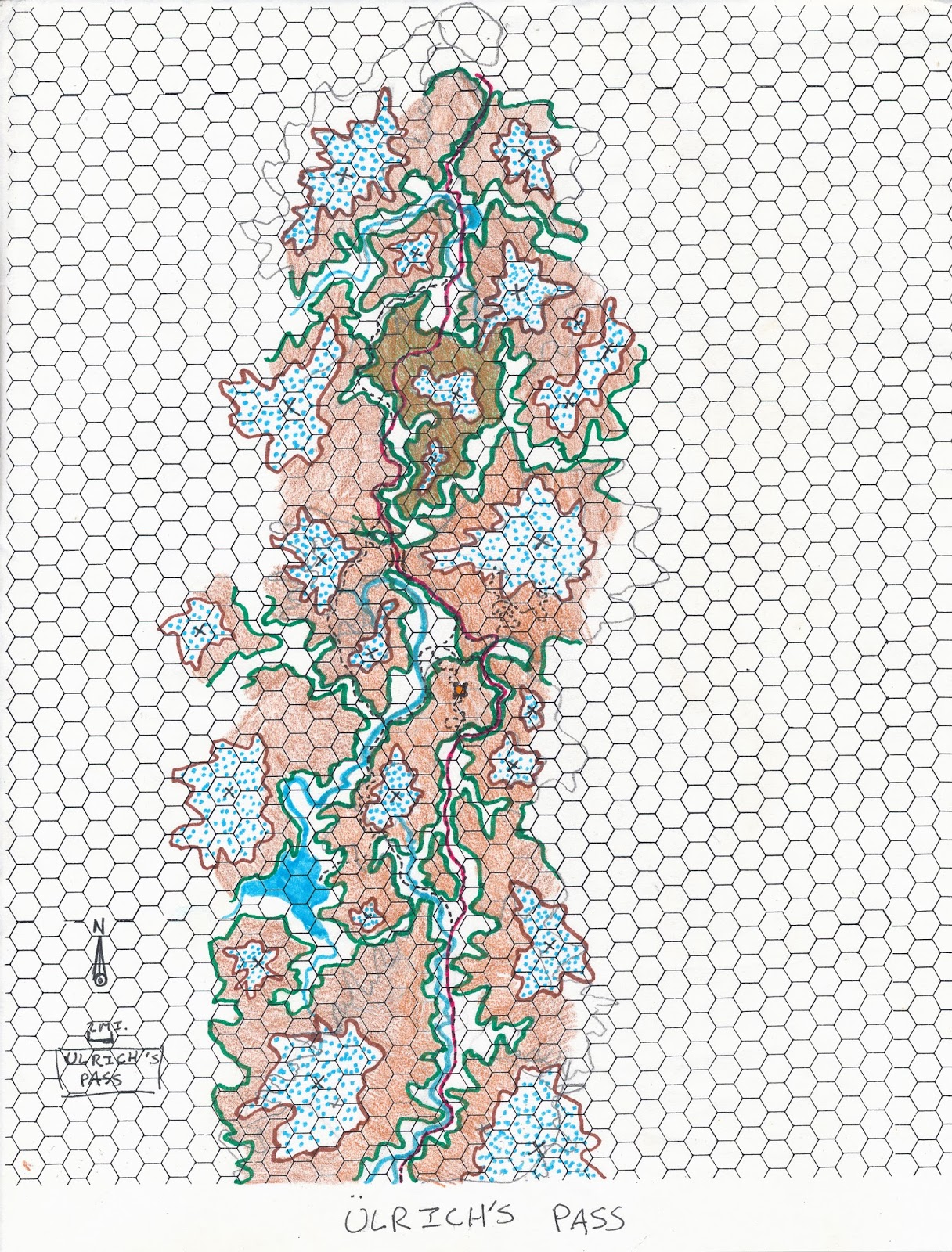
Make-its of Days Past: Map, Ulrich's Pass

Life came on pretty strong this past week. The Wife has been down for the count with a wicked cold, and I have been doing my best to keep up with the weekly chores so she can rest. Of course we didn't actually get much resting done, as we just put an offer on a house this weekend and had it accepted! Holy crap, now we're in the inspection and Escrow scramble.

The point being, I didn't have time to really make anything new this past week. That's not to say I didn't put time into keeping my make-it resolution going. I did put an hour or two worth of work into figuring out an approach to making SketchUp videos for gamers, and I am cultivating ideas on that front, but I didn't end up producing anything worth sharing from the effort. The Wife also got into the make-it act after getting bored with lying around, watching TV (and buying houses). She picked up a paintbrush and applied a base coat of grey paint to an entire set of the Dwarven Forge tiles that I started recently.

So, as a consolation prize for not finishing anything new this week, I give you another map from my very first DM binder. I don't even remember what Ulrich's Pass was supposed to be for, but I definitely dig the topographical feel. Also, hex paper! I found a whole huge sheaf of the stuff in the binder. I distinctly remember struggling to form my opinions on the usefulness of hex vs. square paper back in my 2e days. I definitely dig hex for regional maps like this one, but still prefer quad-rule for dungeons or other tactical maps.


Friday, November 1, 2013

SketchUp for Gamers

The landing at Fenwatch from my last campaign
I've been seeing an increase in the use of SketchUp lately for game mapping. The most common technique seems to involve importing a hand-drawn dungeon map and pushing/pulling it out into three dimensions. You can check out an excellent example of this by mapper, Kevin Campbell here.

Now, I am a huge fan of SketchUp. I deal with it regularly in my day job as a museum exhibit developer. I even teach an annual introductory seminar on it for my former grad school program. So, I like to think of myself as being relatively skilled with the software. Yet in my several attempts to adapt the program for game mapping purposes, I always wind up faltering and leaving a half-produced model waiting to be finished. Why is that?

Hey Geoff... why you no finish Wayshepherd's Guild?

Using SketchUp well takes time. 

I think the name SketchUp is a bit of a misnomer, because if you use the program like a sketch pad, simply drawing in your maps, your model can quickly become cumbersome to work with. The program should really be called "ModelUp", because, as I tell my students, it works best if you "group early and group often". To translate for mapping, each bit of the map should be "sketched" as its own unique group or component. Every doorway, pit trap and blood-soaked altar should be set up as a discrete building block and then plugged into the model. The downside to this technique is that it adds steps, which adds time to the process. If you are in a hurry to get a map done for next week's game, you might want to run with pen and paper. Heck, even at work, we use pencils and sketch pads as much as any software, especially when pressed for time.

Because I'm running an active game, and leaning towards the Lazy DM model for most of my planning, cracking open a SketchUp file for my location-based encounters just hasn't been practical of late. If I were focused on mapping for maps' sake, or making something for publication, it might be a different story, but when in a hurry, it's best to stick with quad ruled paper and pencil.

That being said, SketchUp can offer some definite advantages in certain circumstances such as:

  • Dungeons with overlapping levels. The ability to view models from all angles is a powerful visual tool when dealing with twisting ramps, balconies and other vertically layered environments.
  • Recurring locations. Recurring environments in your game, especially those that might be modified over time can really benefit from the SketchUp treatment. If you set things up well, it can be quick and easy to expand the kitchen on the party's keep, or add battle damage to the mage's tower. If set up poorly, however, such changes could be a nightmare.
  • Established Settings. This is a bit of a Catch-22. SketchUp can get more efficient as you use it, but it can take a while before it is efficient enough to be worth using for a game. Why is this? Well, again, if you are building your models well, you will start to accumulate a library of components that can be quickly plugged into other models as needed. If you don't need to create a creepy statue for your 2nd or 3rd creepy statue dungeon, you can save a lot of time if you slogged through the work in the 1st one.

So, perhaps the best way to start using SketchUp for a game is to build game-like things for fun... without session prep deadlines, or real requirements. Once you have your system down and a library built up, then take the plunge to work it into actual game mapping.

Of course, all of this rumination on SketchUp has both given me an idea and gotten me tempted to try my hand at game mapping in it again. I think that I will take a stab at creating an online version of my intro to SketchUp seminar, but with a focus on creating things for use in RPGs. I don't have a schedule for it, so it will likely be slow to roll out. Nevertheless, I think it could be helpful for those game mappers who want a leg up to use SketchUp well.

In the mean time, if you are currently using SketchUp for fantasy mapping purposes, you can find some furniture and other dungeon/castle elements (along with a couple unrelated projects) for use in your models in my SketchUp warehouse here.

It's like some sort of kobold-filled Ikea


Wednesday, October 30, 2013

Make-its of Days Past: Maps, Falrhea and Ravenwood


Hey hey, map junkies! I've got a couple more maps to share with you from my very first DM's notebook. The first is a very similar, yet slightly different left-justified regional map akin to the one I posted a couple weeks ago! 

I'm not sure how this map relates to the previous region, but I suspect they are part of the same game world. I haven't found a whole lot of notes pertaining to either of these maps. I think high school me was more fond of the drawing aspect of world-building, and likely kept a lot of the relevant story in my brain rather than putting it on paper. Over the course of time, the contextual details, which informed these maps has long-since faded.

That being said, present me really likes the detail past high school me put into the coastline, and is honestly impressed at the decent place names my younger self came up with.

Despite my decent naming skills, "Falrhea" sounds like vertigo-induced dysentery
The second map is of the city of Raven Wood and its surroundings. I dig the smattering of dots and random shapes used to flesh out the population centers. Though I'm not sure high school me really understood how rivers flow. One seems to dead-end in a corn field.


While losing the contextual details behind these places after 20 years in a musty closet is a little sad, these maps also present a sort of blank slate from which to form new stories! I may see if I can't work some of these into the Westerlands at some point.

If you like these ongoing posts of maps from my gaming past, stay tuned. There are still more in my binder and I plan to keep sharing them here. 

On a separate note, in case you missed it, I updated my final Halloween costume post with a couple of better pics taken by my friend, Dan.

Wednesday, October 16, 2013

Make-it of Days Past: Map, Amak Tor and Surroundings


I am on the road this week, so you are getting the travel edition of ROFL Initiative. I rolled for random encounters during my trip today and got one delayed flight, which lead to several extra hours tacked on to my travel time.

Anyway, mapmaster, Dyson Logos has been encouraging everyone on G+ to post mapping creations from their pasts. So I have. Here is another map from my very first game world, that I created back in high school. This map doesn't have quite the polish of the one I posted last week. My river placement and coloring are much sloppier.

One thing that is interesting about this map is that the place names really show the influence that David Eddings was having on my high school self. The heavy use of "K"s in the place names on this map indicates that this is bad country. 


In other news, if you have ever wondered what it takes to start up a video game company, I recommend you check out my buddy Charles' blog. He's been producing games for the likes of Microsoft and Sony for over a decade, but set out on his own recently to start his own company. His blog is tracking the earliest stirrings of his newly full time company. If you're interested in reading about what it takes to get into games AS IT HAPPENS, I highly recommend you check out his shizzle... and his blog.

I've got more maps, more costume updates and a recap/how-to for running an encounter centered on a feast or celebration all in the works, so stay tuned!

Friday, October 11, 2013

Mapping Habits: Cartographic Zoolander

Current Game

High School Game

As I was poring over the recovered maps, notes and drawings from my recently rediscovered high school gaming binder, I noticed something interesting. The map of my current game world bears an uncanny resemblence to the nearly 20 year-old world map from my very first game! Both maps feature:
  • A western ocean 
  • A main coastling running north-south
  • Clusters of islands off the coast 
  • A verdant central landmass  
  • A large mountain range that wraps from the north around along the eastern edge of the map 
  • A desert on the eastern slope of the main mountain range
  • A smaller coastal mountain range
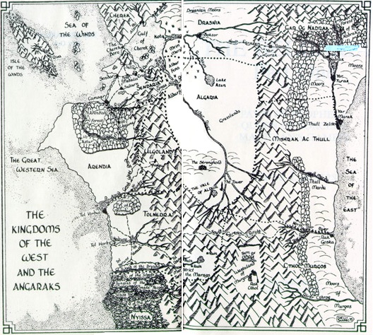
As I thought about this situation further, I started to also notice uncanny similarities in other major fantasy settings. While these settings may not have all of the features mentioned above, they all include a prominent western ocean, and often several of the other features. Take a look at the following maps and tell me there isn't a striking family resemblence!

Tolkien's Middle Earth

The Sword Coast from The Forgotten Realms

The Kingdoms of the West from the Belgariad

Terry Brooks' Shannara

Robert Jordan's world from the Wheel of Time

Brian Jacques' Mossflower

IT'S THE SAME FACE!

I FEEL LIKE I'M TAKING CRAZY PILLS! Why!? Why do so many of the characteristics in these maps overlap? What compels all of these various authors, myself included to assign similar spatial structures to their worlds? I have a couple possible theories...

Friday, September 20, 2013

Layers of Places Past: Creating Ruins with Purpose

The BIGGEST Henge in the WORLD!
This is yet another post for CampaignMastery's Location blog carnival! Hope you enjoy!

Today, I am going to elaborate on an excellent suggestion from Realmwright on my previous post. I am going to talk a bit about why ruined locations show up where they do, and how their past might inform their present desolation.

The fantasy genre in general, and fantasy games in particular, spend a lot of time focusing on places from the past. Authors like Tolkien and Terry Brooks build their worlds around elaborate histories of rise and ruin. Characters in videogame and tabletop RPGs spend much of their time poking through lost catacombs and ruined castles. The thing is, all that was old was new at one time, and when it was, these ancient places likely served a purpose.

I have a love-hate relationship with many dungeon maps, especially those which follow an old-school aesthetic. Maps are a lot of fun to look at in general, to imagine what a place or space really looks like based on its top-down representation, and old school dungeon maps have an elegant simplicity about them. The problem is, they often seem to be a tangle of rooms and corridors built for no discernible reason!

Now, where the heck is the bathroom?

Sure, the person who dreamed up the dungeon, always says there's a purpose. The map above is clearly a temple of the ancient Blue Oyster Cult. The architecture of Blue Oys is often characterized by its meandering lines and maddening lack of doors in places where they should exist. Archaeologists believe the structure was designed to amplify the sound of the cowbells used in the cult's mysterious rituals.

Seriously, though, who builds like this!? And "insane wizards" is an answer that you can get away with exactly once in your game! I'm looking at you, Undermountain!

This kind of random dungeon layout, while interesting to look at in a circuit board kind of way, really drives me nuts. If you haven't read it yet, Bartoneus, over at Critical Hits has created one of my absolute favorite blog series, called The Architect DM, which is all about creating fantasy designs with a purpose and is a useful way to counter the random dungeon sprawl. I highly recommend you read it, bookmark it, and reference it often when creating your own locations.

When I approach the design of a ruined structure, I always try to start before it was a ruin. I ask myself the following questions:

Monday, September 16, 2013

Make-it Monday: Map, Elven Museum

This post is yet another entry in this month's Campaign Mastery location blog carnival.

Hey hey, map fans! Look at what we have here! Some of you who started following during April's Mapstravaganza mentioned that you wanted some more. Well, I broke out the ol' Prismacolor markers this weekend and drew you up something nice!

This map represents an ancient, ruined elven museum that I ran my players through in my game. I really dug the idea of running a Night at the Museum-style adventure, and when playing in a setting where magic is a reality, it doesn't take a lot to apply it to the "exhibits come alive" trope. Read on to learn a little more about how things were set up in my game, or get a blank copy of the map here.

Friday, September 13, 2013

Pinteresting Locations


I am a busy dude, and as I have become more experienced at running my regular D&D game, I have found myself trimming the fat from my prep time whenever possible. One of the best tricks that I have added to my DM toolbox deals with creating locations. In the past, I would spend hours, if not days or weeks painstakingly dreaming up and then drawing out the maps for location-based encounters. I would agonize over whether the dimensions for different vertical levels in a structure lined up properly, or whether there were enough fields around a city to maintain its population. I really didn't have time for that kind of crap, and my players didn't really pay attention to it. They wanted cool places to get into fights, and that's it.

Then I realized, why spend all that time fighting writer's block to dream up totally unique places, when you can draw inspiration from the fantastic places already out there!? I set up a Pinterest board called Gamespiration, and over the months that I've had it, the board has filled up largely with photos and illustrations of fantastic locations. The pictures are great for breaking through creative blocks that might otherwise result in yet another fight in an 8x8 room with a couple pillars.

Let me give you an example of how I pulled several existing images together to inspire the location where the final climactic episode of my last campaign took place.

First, I knew I wanted the battle to take place outside a ruined city on a plateau up against a glacier, out of which were running rivers of blighted water. But drawing a city map can take FOR-EV-ER. So I looked around until I found Ani.


I kept the basic shape, changed the fortifications at the north edge to the foot of the glacier and converted some of the landmarks into sites appropriate for my particular ruin.

I also knew I wanted a Helm's Deep style fortress set into the foot of the glacier, so I grabbed this image and a couple others for visual inspiration.


I also grabbed this one for a top-down map.


I ignored the underground cutaway on the bottom of the map, replaced the steps and altar at the top with a keep, and added a few more breaches in the walls from time and previous battles. All-in-all the modifications were much quicker than dreaming it up from scratch.

When my players headed to the ruined city to scout things out, they went poking around in some ice caves looking for a back entrance to the mines they thought might be the source of the evil blight. I took my inspiration for the cave environment from this image.


The beautiful thing about using Pinterest to inspire location is that you can draw from rich visual resources, which can add depth to your locations' descriptions, or even just be shown at the table. "You enter an icy cave that looks like this."

You also can be laying the foundation for incredible locations outside of your prep time without disrupting your usual activities. Anytime you see a cool or potentially inspiring image on Facebook, in an article you're reading or anywhere else online, you can just use the Pinterest plugin in your web browser to toss the image onto your board. When it comes to prepping a location, you then have a one stop shop to get things rolling!


Friday, September 6, 2013

Tips for Generating Location Names for Fantasy Settings

Map of the United States of the Home Ruler from the Atlas of True Names.

Coming up with location names is something most fantasy authors, gamemasters and world-builders must do from time to time. Making those names compelling in a way that adds to your world rather than detracting from it can be daunting, and justifiably so. If you fudge a place name, you may very well be stuck with a blight on your world. A dark spot cursed with a name that is some combination of silly, burdensome to pronounce, or otherwise detrimental to your audience's sense of immersion.

I face this problem whenever I look to send my D&D players off to explore a new part of my world. Fortunately, I have developed a set of guidelines that I use when crafting new location names that have served me well.

Obvious names are not necessarily bad. Places are typically named after something and that something is often rather obvious. Some quick real world examples I can think of include:
  • Washington (a guy's last name)
  • Bath (named for a prominent recreation spot)
  • Salt Lake City (prominent natural feature)
  • Capetown (the city's location plus a word that means city)
  • Fort Collins (named for the town's original function)


If you go this route, you can come up with some pretty decent place names, especially if you use less common synonyms or slightly change certain words. Some examples from my game world include:
  • Stillford (a town on a stream with a distillery)
  • Fenwatch (an outpost by a swamp)
  • Thunder vale (a valley with a roaring waterfall)
  • Lastholt (named for a stronghold that served as a last stand. Last+hold change the "d" to a "t")


Keep the names short! Even well established fantasy writers get a little carried away and occasionally come up with names that become mental and verbal stumbling blocks for those who encounter them. The Drow city of Menzoberranzan from the Forgotten Realms is a classic example of this problem. At five syllables, it's a pain in the butt to say!

Think about it! It's tough to find a real world city with that many syllables! After some consideration, I came up with Minneapolis, Philadelphia and Alexandria, as real world equivalents and all of those cities have at least one pair of syllables that can be blended together to effectively shorten the pronounciation. In fact, if a place DOES have an exceptionally long name, you can bet someone will try to find a way to shorten it! Philly, L.A., Frisco, etc. Maybe that's why the Drow are so cranky! They live in an obnoxious to pronounce city with no decent nickname!

I know, I know… We're talking fantasy, not reality and the elves and ponytaurs are supposed to have exotic and elegant sounding place names. That's great! You can do that without lots of syllables! Believe me.

When you simply must get exotic, translators are your friend! Remember how in part one up there, I said places mean something? Well, one of my favorite tricks is to run common descriptive words or phrases through Google Translate or sometimes elven or other fantasy translators to come up with place and character names. With Google Translate, I pick a real world culture to serve as an analog of the fantasy culture that named the spot, and play around until I get something that sounds good. For example, "Wood City" in Welsh is "Dinas Pren"… not a bad name for an elven town. Incidentally, "Salt Lake" in Welsh is "Llyn Halen", which is not to be confused with its inferior successor "Llyn Hagar". 

Anyway, the system is not perfect, but if you stick with the cultural analog method, you can come up with groups of exotic sounding place names that sound like they have a consistent linguistic history in your game world… because, in reality, they do!

Those are just a couple quick guidelines that I like to apply when coming up with place names for my world. They have served me well so far, and if you give them a try, I hope they work for you as well.

Monday, May 6, 2013

Make-it Monday: A to Z Compilation Books

One of the big reasons for using maps as my A to Z theme was to build a collection of stock locations for use in my game. For this week's Make-it Monday, I decided to compile all of my hand drawn originals, along with printouts of the parchment-textured finals into two artist portfolios. Unfortunately, I couldn't find a portfolio at my local art store with enough pages to include everything in one volume. Still, I am pleased with how things turned out.

The old label maker comes in handy once again

Here's the interior layout turned to a couple of my favorites from the challenge.

Tucked away snug on my RPG shelf.
I don't know that I've ever shown this, but this is my RPG bookshelf all within arms reach of my GM spot.
The plastic bins on the bottom two shelves are all packed with minis.
There are a few leftover pages in each portfolio, so I may work up a title page and table of contents for each. It's really not necessary, but it would look cool.

Friday, May 3, 2013

Collapse on the Couch and Reflect


This is my reflection post for the 2013 April A to Z Challenge.

I would like to begin by welcoming everyone to my non-Challenge blog. I feel like blog personalities change slightly when not under the pressure of A to Z. Like getting home from work, or a fancy dinner party with a bunch of strangers. After A to Z, the blog's shoulders relax, it kicks off its shoes, cracks open a beer and maybe lets out a little fart or something. You get to see it when it is not trying to be "on". Sometimes that change is a little different from the vibe given off during the A to Z.

This past A to Z was all about maps for me, but ROFL Initiative is more than a place for pretty maps. Yes, I draw on occasion, but this space is mostly a celebration of all things nerdy. Of things that would make jocks of the 1980s want to beat me up. I would elaborate further, but this past week, Wil Wheaton posted a blog, a video and a picture that also happen to sum up what I strive for in a far more eloquent way than I could on my own. 

You'll be Safe Here, by Dryponder
If you don't follow Wil already, you should check his stuff out. You might like what he has to say. In the mean time, welcome. I'm glad you're here.

On to the reflecting!

This was my third year participating in the A to Z Challenge. In a lot of ways this year was wildly successful.
  • My visible followers grew by 50% over the course of the month.
  • I smashed my previous monthly page-view record by 200% and broke 10,000 pageviews for the first time.*
  • By hand drawing my maps, I actually got myself away from my computer in the evenings and avoided the temptation to work on personal projects during work time.
  • I wound up with a collection of stock maps that I have already begun putting to use in my D&D game. This past Monday, my players battled a bunch of undead beasties at an altar.
  • Using maps as my theme helped prevent me from phoning in my posts while in the thick of it. In years past, I've always been tempted to just get a blog done regardless of how crappy it was. Not so with the maps.
  • I added quite a few new blogs to my feed reader.

 *This was largely due to a wonderful fellow blogger posting about my project on Reddit, which led to it trending as high as #3 on the RPG boards for a day. It'll be interesting to see where things stand post spike.

However, there were also a lot of things that continue to frustrate me about the Challenge, or at least make me pause and say, "I wonder…"
  • I had a heck of a time making it to other people's blogs.
  • When I did find time, I found myself wondering if I should go to new blogs, or revisit the ones I was really digging. I definitely felt like I didn't have time to do both.
  • It generally took longer to make the maps than it otherwise would to write a blog, so more of my time was consumed by the challenge.
Very soon I will add this year's posts to my A to Z archive page. If you would like to check out my entries from years past, you can find them there in convenient lists! Do I think the Challenge was worth it this year? Yes! Will I do it again next year? Not really sure yet. I probably wont know for a while now.

Oh, if you didn't get enough alphabetizing during April, check out Realmwright, who has decided to run a May to Z blog challenge!


Tuesday, April 30, 2013

Z is for Ziggurat


This is it! The final map of my April A to Z mapstravaganza and my third successful completion of the A to Z challenge. The ziggurat, a mighty monument with a lot of steps that take a lot of effort to climb. What lies in the chamber at the top? Steps down... perhaps to adventure!

Big thanks to everyone who joined me on this A to Z challenge! I found many new blogs to follow and it looks like I attracted many new readers. I will probably take a break from posting... perhaps doing a wrap-up on Friday.

For those of you who joined for the challenge, the mapstravaganza represented an escalation of my New Year's resolution, which was to make a thing a week. I intend to continue with my make a thing a week challenge. The things I come up with get posted every Monday as part of my ongoing Make-it Monday series. Some will be maps. Some will be drawings. Some will be crafts. Some I haven't thought of yet.

Okay, get your printable ziggurat here.

I'm going to stop typing now.

Geoff

Monday, April 29, 2013

Y is for Yeti's Cave


High in the frozen mountains, perhaps near the icy chasm, a yeti has made its lair in a secluded cave. The cave floor is littered with the leavings of the yeti's hunts. Perhaps the beast has discarded some unknown treasures from unwary travelers it has slain. Or if your in the market for a nearly complete dire elk skeleton...

Just one more day left in the A to Z Challenge!

Get a printable version of the yeti's cave here.

Saturday, April 27, 2013

X is for Xill's Nest


One of the beauties of D&D is there are tons of things that make use of obscure letters like X! The Xill is a race of 4-armed lizard-like beings that live on the ethereal plane. They are evil raiders who wait in ambush for creatures on the material plane to pass by. They then cross over the planar boundary, subdue their prey and drag them back to the ethereal plane. Xill reproduce by implanting their eggs in their victims (Alien or wasp-style) When the eggs hatch, the Xill larvae devour their host from the inside.

The Xill nest takes advantage of their ethereal nature. It is located on the ethereal plane next to a material road where prey is plentiful. The brood chamber and that of the Xill leader have no doors. This allows ethereal Xill to pass while trapping material beings within.

With that, we are done with the final full week of the challenge. Just two more posts to go!
Get a printable version of the Xill's nest here.


Friday, April 26, 2013

W is for Waterfront


or wharf... or whatever.

I'd like to give a big shoutout to Dyson Logos and Dante for posting about my A to Z mapstravaganza on various sites yesterday. Apparently the Reddit RPG forum got ahold of it and my traffic spiked to the point that I got a month's worth of traffic in a single day!

Today's map depicts a seedy fantasy waterfront, complete with vikingesque longship in honor of the Swedish invasion my site underwent yesterday. I love the potential weirdness that can take place in dockside neighborhoods. The combination of ships coming in from exotic locales, and ships headed out carrying folks with places to go, folks with people to flee and folks just looking for adventure makes for a crab pot of excitement just waiting to boil over.

Speaking of crab pots, I once worked up an in-game dockside bar called Peggy's. It was run by a dwarf with a peg leg. He had lost his leg in a battle with a giant crab, but managed to take one of the crab's claws in vengeance. He felt fine about it until he learned that crabs grow their claws back. Now ol' Peggy makes regular pilgrimages to re-take his nemisis' claw. The walls of his bar are festooned with the fruits of his labor.

At some point, I would also like to create a seaside bar run by catfolk. It would be called the Crusty Starfish. If you own a cat, I'm sure you get it.

Oh, also, now my 20% gray pen is starting to fade, so I only used it for small bits of shading. I did the shady sides of the rooftops after the fact in Photoshop. Do I go to the art store again or try to get through these last three maps?

Get a printable version here.

Thursday, April 25, 2013

V is for Village Square


It all starts here. The ubiquitous village has been the jumping off point for countless D&D games. My campaign started in a tavern in a village much like this one. Cliche? about as much as you can get, but it wasn't for my players who had never played before that.

Just four more days left!

Get a printable version here.


Wednesday, April 24, 2013

U is for Undercity


Beneath every city lies a world of secrets where things discarded by accident or intention go to find new purpose. In the sewers, theives and the destitute can find refuge from judgment and prying eyes.

U is also for "Uh oh, out of ink." My 50% gray marker I bought specifically for the A to Z challenge ran out of ink partway into shading this drawing. I had to continue with the 80% gray marker and then adjust the curves in Photoshop. It's kind of cool that I managed to draw a pen dry in less than a month, but it does mean I'll be stopping at the art store before moving on to V.

Get a printable version here.

Tuesday, April 23, 2013

T is for Thunder Vale


Thunder Vale is a valley high in the Cloud Peak Mountains, named for the booming echoes made by two waterfalls pouring over a cliff at its southern end. The stronghold featured yesterday is located atop the cliff in Thunder Vale. In my game world, the stronghold and vale were given to my players to serve as their base of operations. When they found it, the stronghold was in partial ruins, and a group of refugees had settled nearby fleeing a plague (of the zombifying sort) that was sweeping the land. The players have begun to fix up the keep and many of the refugees have chosen to stay, beginning to establish agriculture and herding within the vale.

Get a printable version here.