 |
| Current Game |
 |
| High School Game |
As I was poring over the recovered maps, notes and drawings from my recently rediscovered high school gaming binder, I noticed something interesting. The map of my current game world bears an uncanny resemblence to the nearly 20 year-old world map from my very first game! Both maps feature:
- A western ocean
- A main coastling running north-south
- Clusters of islands off the coast
- A verdant central landmass
- A large mountain range that wraps from the north around along the eastern edge of the map
- A desert on the eastern slope of the main mountain range
- A smaller coastal mountain range
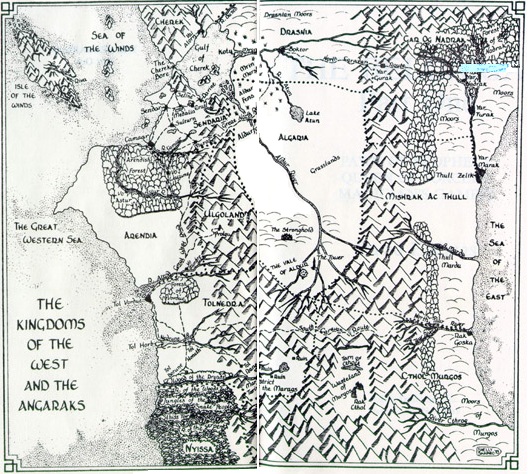
As I thought about this situation further, I started to also notice uncanny similarities in other major fantasy settings. While these settings may not have all of the features mentioned above, they all include a prominent western ocean, and often several of the other features. Take a look at the following maps and tell me there isn't a striking family resemblence!
I FEEL LIKE I'M TAKING CRAZY PILLS! Why!? Why do so many of the characteristics in these maps overlap? What compels all of these various authors, myself included to assign similar spatial structures to their worlds? I have a couple possible theories...
Theory 1: The Tolkien Effect
Though fantastic writings had been puttering along for many years, if not centuries depending on how far you trace the origins, Tolkien's publication of Lord of the Rings revolutionized the genre. It legitimized high fantasy as a commercially viable genre, established many of the tropes and solidified others that have persisted to this day. It expanded fantasy beyond the pulps and childrens tales, and set it off in a direction that has changed little (in a broad sense) to this day.
The map of Tolkien's Middle Earth is the earliest of those I listed. Is it possible that its spatial structures burned their way into the subconscious of myself, along with these and other burgeoning fantasy authors' notions of setting, just as his forms of magically adept, graceful elves; gruff, axe-swinging dwarves; and vicious, militaristic orcs and goblins did for notions of character?
Theory 2: The Western Civilization Effect
 |
| ??? |
The fantasy stories set in the worlds mentioned above are all based, to some degree, on an analogy of medieval European society. They have nobles who live in castles, warriors in armor who swing swords, with some significant twists such as all the characters being woodland critters (Jacques) or creepy remnants of ancient technology running amok (Brooks) but all of these world exhibit some of the tropes of medieval European society. Is it any wonder then that the basic land structure looks somewhat like Europe? You have a western ocean, often with a large island or islands hovering just off the northwest coast. To the east lies a mysterious other land that is difficult to traverse and often contains ever more exotic or hostile sights.
[EDIT]
Someone over in the G+ Tabletop RPGs forum shared this link that shows I am not
the first or only person to notice this.
Theory 3: Stay Close to Home
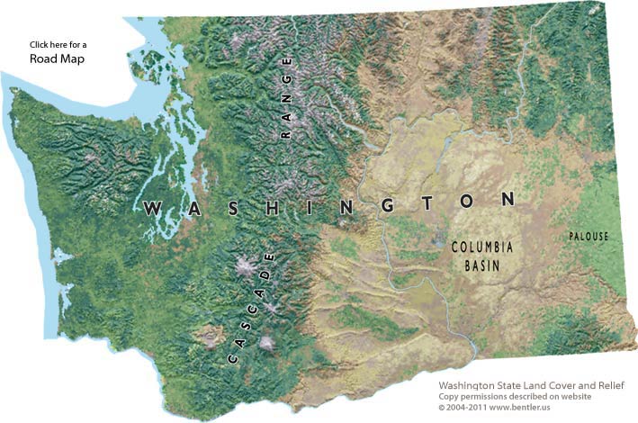 |
| ??? |
This theory does not necessarily apply to these other authors, but I know that my maps bear some resemblance to the structure of Washington State where I live. Verdant western land, with a western ocean, drier hotter eastern land across a mountain range. While I know Tolkien was attempting to write a sort of British mythology, I haven't looked into it enough to know whether he was attempting to lay out Middle Earth in an analogous way. This theory does not necessarily hold for the other authors who are mostly American, but not from Washington or even the west coast.
Theory 4: The Pokemon Effect
Perhaps the structure of these maps originates from a need to "Catch 'em all" when it comes to fantasy world tropes. These worlds tend to have a mix of civilized lands with adjacent borders to establish potential conflict. A large ocean with an unknown shore on one edge, which can serve as a source of the unknown which might manifest as invaders, or serve as a draw for the protagonists should the story or stories outgrow the established land area.
The mountains serve a similar purpose, but tend to represent a border between or origin of evil, and/or the thought to be evil other. As the heroes set off on their journey, they often find themselves venturing into or across these mountains. The rest of the lands in these worlds are often a mishmash of open grassland to serve as a source of equestrian societies, forest lands for the archer types and icy north lands for the viking analogs and/or dwarves.
Conclusion?
I don't really have a definitive answer to this cartographic conundrum. It may even be all in my mind, a bit of
pareidolia apophenia casting phantom patterns in my brain. My gut reaction is that a mix of all the factors I outlined is to blame. I know that I was greatly influenced both by my immediate surroundings and by the authors I was reading, and I am sure this influence spread to my mapping as well.
What do you think? Do you notice any of these factors at play in your own worldbuilding?


I've often had similar thoughts. I think the Western Civilization Effect is probably the granddaddy of all the rest, since the map of Europe was Tolkien's geographical inspiration. I like your notions about the influence of the Washington map; I've often thought Washington would make a good fantasy setting, especially when driving through the Cascades; they feel very Misty-Mountainy sometimes.
ReplyDeleteI don't know about you or any of the authors, but I'm left-handed and draw most of my oceans to the east. That may be a piece of it also.
ReplyDeleteThat may very well be a factor. The link I added after the fact in the section about Western Civ mentions some of the potential influence of right-handedness on the justification of the map, so left-handedness might also influence the layout.
DeleteI talked to my left-handed little brother, and he orients maps like I do. He also pointed out that coast-mountains-desert (in whatever nsew oreintation) makes sense, due to the rain shadow effect.
DeleteI agree with your reasoning, I think all of those are pretty reasonable influences.
ReplyDeleteMine are a little different though - most of mine have been eastern coastlines, probably due to the American History Class effect when I was first drawing them. Additionally Greyhawk and the Known World were both Eastern coastlines and those were big players in my early mapping experiments.
More recently a lot of my doodles have been more Mediterranean Sea-ish but that was a more conscious choice on my part.
I recognized my own strong desire to imitate this pattern, and deliberately contradicted it when creating my current fantasy setting. The map for my LARP setting, though, fits the bill precisely. (The former is my own art skills at work; the latter is the work of another member of the committee.)
ReplyDeleteI've long since noticed the same thing, and have attributed it to the Tolkien effect: the inspiration for all modern fantasy RPGs. That said, Tolkien was influenced by Western Culture, certainly.
ReplyDeleteI don't know about Pokemon, but I think you're correct about the rest of them. I hadn't ever thought of the Pacific Northwest as being much the same (coast, forest, and eastern desert) but now it makes perfect sense!
ReplyDeleteI think a lot of it has to do with subconscious mimicry and the rest is sticking with what you know. For instance, if I were to do a past-apoc setting, it would be a decimated American West - because that's where I'm from and where lots of early nuke tests were done.
I have noticed this. IMO this is explainable in part because there are only so many ways to orient a continental map. Which coast - west, east, north, south, or a corner where two of them meet? I think N-S orientations are more popular partly because there is variety in climate.
ReplyDeleteThe other major variant is east cost: sea to the east and south, desert to the east. Often european cultures mirrored (arab analogues to the west). Seem in Greyhawk and Mystara, the Riddlemaster of Hed, Narnia, etc. Less common but still a very recognizable pattern, the mirror image of the West Coast version. Likely an east coast usa influence, especially when it includes obvious "great lakes" and a "mississippi" river. (True of both greyhawk and mystara)